Please use this identifier to cite or link to this item:
http://hdl.handle.net/2122/2107| DC Field | Value | Language |
|---|---|---|
| dc.contributor.authorall | Salvi, S.; Istituto Nazionale di Geofisica e Vulcanologia, Sezione CNT, Roma, Italia | en |
| dc.contributor.authorall | Atzori, S.; Istituto Nazionale di Geofisica e Vulcanologia, Sezione CNT, Roma, Italia | en |
| dc.contributor.authorall | Brunori, C. A.; Istituto Nazionale di Geofisica e Vulcanologia, Sezione CNT, Roma, Italia | en |
| dc.contributor.authorall | Doumaz, F.; Istituto Nazionale di Geofisica e Vulcanologia, Sezione CNT, Roma, Italia | en |
| dc.contributor.authorall | Ricciardi, G. P.; CNR - IREA, Napoli, Italy | en |
| dc.contributor.authorall | Solaro, G.; CNR - IREA, Napoli, Italy | en |
| dc.contributor.authorall | Stramondo, S.; Istituto Nazionale di Geofisica e Vulcanologia, Sezione CNT, Roma, Italia | en |
| dc.contributor.authorall | Tolomei, C.; Istituto Nazionale di Geofisica e Vulcanologia, Sezione CNT, Roma, Italia | en |
| dc.contributor.authorall | Lanari, R.; CNR - IREA , Napoli, Italy | en |
| dc.contributor.authorall | Pepe, A.; CNR - IREA, Napoli, Italy | en |
| dc.contributor.authorall | Ferretti, A.; Tele Rilevamento Europa S.R.L. Milano, Italy | en |
| dc.contributor.authorall | Cespa, S.; Tele Rilevamento Europa S.R.L. Milano, Italy | en |
| dc.date.accessioned | 2007-05-10T07:56:49Z | en |
| dc.date.available | 2007-05-10T07:56:49Z | en |
| dc.date.issued | 2007-04-15 | en |
| dc.identifier.uri | http://hdl.handle.net/2122/2107 | en |
| dc.description.abstract | VELISAR (Ground VELocity in Italian Seismogenic Areas) is a scientific research initiative aimed at producing a map of the ground deformation over most of the seismogenic areas of Italy, using the space-based technique of multitemporal Synthetic Aperture Radar Interferometry (InSAR). The ground velocities derived from InSAR data will be validated by means of ground based data obtained from GPS, optical leveling, seismological and neotectonic studies. The scope of the project is to produce a high-resolution ground deformation dataset useful to model the seismic cycle of strain accumulation and release at the scale of the single faults. The main objective of VELISAR is to produce maps of ground velocity with the following characteristics: - A ground resolution better than 100 m. - Average uncertainty of LoS velocity measurements smaller than 2 mm/yr . - Temporal coverage of at least 7 years. - Retrieval of East and Up components from ascending and descending LoS. VELISAR will exploit the potential of the long time series (1992-2000) of ERS InSAR data maintained in the ESA archives; over 4000 ERS images will have to be processed to accomplish its objectives. Presently, two InSAR techniques for the measurement of slow ground deformation are used in VELISAR: the Permanent Scatterers (PS) technique developed by the Politecnico of Milano (POLIMI), and the Small Baseline Subset (SBAS) technique, developed by the Institute for Remote Sensing of Environment (IREA-CNR), in Napoli. The PS technique is applied by TRE preferably over areas characterised by diffuse temporal decorrelation due to, for instance, erodible lithologies, agricultural land use and strong vegetation cover. In these areas we expect to obtain good temporal coherence mainly on sparse point scatterers. The SBAS technique is applied by IREA and INGV mostly over areas where limited temporal decorrelation is expected: urban areas, scarcely vegetated areas. The ground resolution at which these data are originally processed is 80 m. An important goal of the VELISAR initiative is to disseminate the information on the InSAR-derived ground velocity measurements, to the scientific community and to the public in general. Such goal is accomplished through a dedicated web site, where the velocity maps of the italian seismogenic areas will be progressively published. We will present the initiative, its scope and objectives, the technical details and the data processing strategies, and some examples of ground velocity maps. | en |
| dc.format.extent | 3029267 bytes | en |
| dc.format.mimetype | image/png | en |
| dc.language.iso | English | en |
| dc.relation.ispartof | European Geoscience Union General Assembly 2007 | en |
| dc.subject | SAR | en |
| dc.subject | Inteferometry | en |
| dc.subject | Small Baseline Sunset | en |
| dc.subject | SBAS | en |
| dc.subject | Permanent Scatterers | en |
| dc.subject | PS | en |
| dc.subject | Ground Velocity | en |
| dc.subject | seismogenic area | en |
| dc.title | The VELISAR initiative for the measurement of ground velocity in italian seismogenic areas | en |
| dc.type | Poster session | en |
| dc.description.status | Published | en |
| dc.subject.INGV | 04. Solid Earth::04.03. Geodesy::04.03.01. Crustal deformations | en |
| dc.subject.INGV | 04. Solid Earth::04.03. Geodesy::04.03.06. Measurements and monitoring | en |
| dc.subject.INGV | 04. Solid Earth::04.03. Geodesy::04.03.07. Satellite geodesy | en |
| dc.subject.INGV | 04. Solid Earth::04.03. Geodesy::04.03.09. Instruments and techniques | en |
| dc.description.ConferenceLocation | Vienna, Austria | en |
| dc.description.fulltext | open | en |
| dc.contributor.author | Salvi, S. | en |
| dc.contributor.author | Atzori, S. | en |
| dc.contributor.author | Brunori, C. A. | en |
| dc.contributor.author | Doumaz, F. | en |
| dc.contributor.author | Ricciardi, G. P. | en |
| dc.contributor.author | Solaro, G. | en |
| dc.contributor.author | Stramondo, S. | en |
| dc.contributor.author | Tolomei, C. | en |
| dc.contributor.author | Lanari, R. | en |
| dc.contributor.author | Pepe, A. | en |
| dc.contributor.author | Ferretti, A. | en |
| dc.contributor.author | Cespa, S. | en |
| dc.contributor.department | Istituto Nazionale di Geofisica e Vulcanologia (INGV), Sezione ONT, Roma, Italia | en |
| dc.contributor.department | Istituto Nazionale di Geofisica e Vulcanologia (INGV), Sezione ONT, Roma, Italia | en |
| dc.contributor.department | Istituto Nazionale di Geofisica e Vulcanologia (INGV), Sezione ONT, Roma, Italia | en |
| dc.contributor.department | Istituto Nazionale di Geofisica e Vulcanologia (INGV), Sezione ONT, Roma, Italia | en |
| dc.contributor.department | CNR - IREA, Napoli, Italy | en |
| dc.contributor.department | CNR - IREA, Napoli, Italy | en |
| dc.contributor.department | Istituto Nazionale di Geofisica e Vulcanologia (INGV), Sezione ONT, Roma, Italia | en |
| dc.contributor.department | Istituto Nazionale di Geofisica e Vulcanologia (INGV), Sezione ONT, Roma, Italia | en |
| dc.contributor.department | CNR - IREA , Napoli, Italy | en |
| dc.contributor.department | CNR - IREA, Napoli, Italy | en |
| dc.contributor.department | Tele Rilevamento Europa S.R.L. Milano, Italy | en |
| item.openairetype | Poster session | - |
| item.cerifentitytype | Publications | - |
| item.languageiso639-1 | en | - |
| item.grantfulltext | open | - |
| item.openairecristype | http://purl.org/coar/resource_type/c_18cf | - |
| item.fulltext | With Fulltext | - |
| crisitem.author.dept | Istituto Nazionale di Geofisica e Vulcanologia (INGV), Sezione ONT, Roma, Italia | - |
| crisitem.author.dept | Istituto Nazionale di Geofisica e Vulcanologia (INGV), Sezione ONT, Roma, Italia | - |
| crisitem.author.dept | Istituto Nazionale di Geofisica e Vulcanologia | - |
| crisitem.author.dept | Istituto Nazionale di Geofisica e Vulcanologia (INGV), Sezione ONT, Roma, Italia | - |
| crisitem.author.dept | Istituto Nazionale di Geofisica e Vulcanologia (INGV), Sezione OV, Napoli, Italia | - |
| crisitem.author.dept | IREA-CNR, Naples, Italy. | - |
| crisitem.author.dept | Istituto Nazionale di Geofisica e Vulcanologia (INGV), Sezione ONT, Roma, Italia | - |
| crisitem.author.dept | Istituto Nazionale di Geofisica e Vulcanologia (INGV), Sezione ONT, Roma, Italia | - |
| crisitem.author.dept | CNR-IREA | - |
| crisitem.author.dept | Universita` Federico II, Dipartimento di Ingegneria Elettronica e delle Telecomunicazioni | - |
| crisitem.author.dept | Tele Rilevamento Europa, s.r.l., Milano, Italy | - |
| crisitem.author.orcid | 0000-0002-7776-6544 | - |
| crisitem.author.orcid | 0000-0002-5031-9904 | - |
| crisitem.author.orcid | 0000-0003-0862-8161 | - |
| crisitem.author.orcid | 0000-0002-9554-9121 | - |
| crisitem.author.orcid | 0000-0002-8692-7258 | - |
| crisitem.author.orcid | 0000-0003-0163-7647 | - |
| crisitem.author.orcid | 0000-0001-7378-0712 | - |
| crisitem.author.orcid | 0000-0002-7843-3565 | - |
| crisitem.author.parentorg | Istituto Nazionale di Geofisica e Vulcanologia | - |
| crisitem.author.parentorg | Istituto Nazionale di Geofisica e Vulcanologia | - |
| crisitem.author.parentorg | Istituto Nazionale di Geofisica e Vulcanologia | - |
| crisitem.author.parentorg | Istituto Nazionale di Geofisica e Vulcanologia | - |
| crisitem.author.parentorg | Istituto Nazionale di Geofisica e Vulcanologia | - |
| crisitem.author.parentorg | Istituto Nazionale di Geofisica e Vulcanologia | - |
| crisitem.classification.parent | 04. Solid Earth | - |
| crisitem.classification.parent | 04. Solid Earth | - |
| crisitem.classification.parent | 04. Solid Earth | - |
| crisitem.classification.parent | 04. Solid Earth | - |
| crisitem.department.parentorg | Istituto Nazionale di Geofisica e Vulcanologia | - |
| crisitem.department.parentorg | Istituto Nazionale di Geofisica e Vulcanologia | - |
| crisitem.department.parentorg | Istituto Nazionale di Geofisica e Vulcanologia | - |
| crisitem.department.parentorg | Istituto Nazionale di Geofisica e Vulcanologia | - |
| crisitem.department.parentorg | Istituto Nazionale di Geofisica e Vulcanologia | - |
| crisitem.department.parentorg | Istituto Nazionale di Geofisica e Vulcanologia | - |
| Appears in Collections: | Conference materials | |
Files in This Item:
| File | Description | Size | Format | |
|---|---|---|---|---|
| Salvi_et_al_Vienna_EGU07.png | 2.96 MB | image/png | 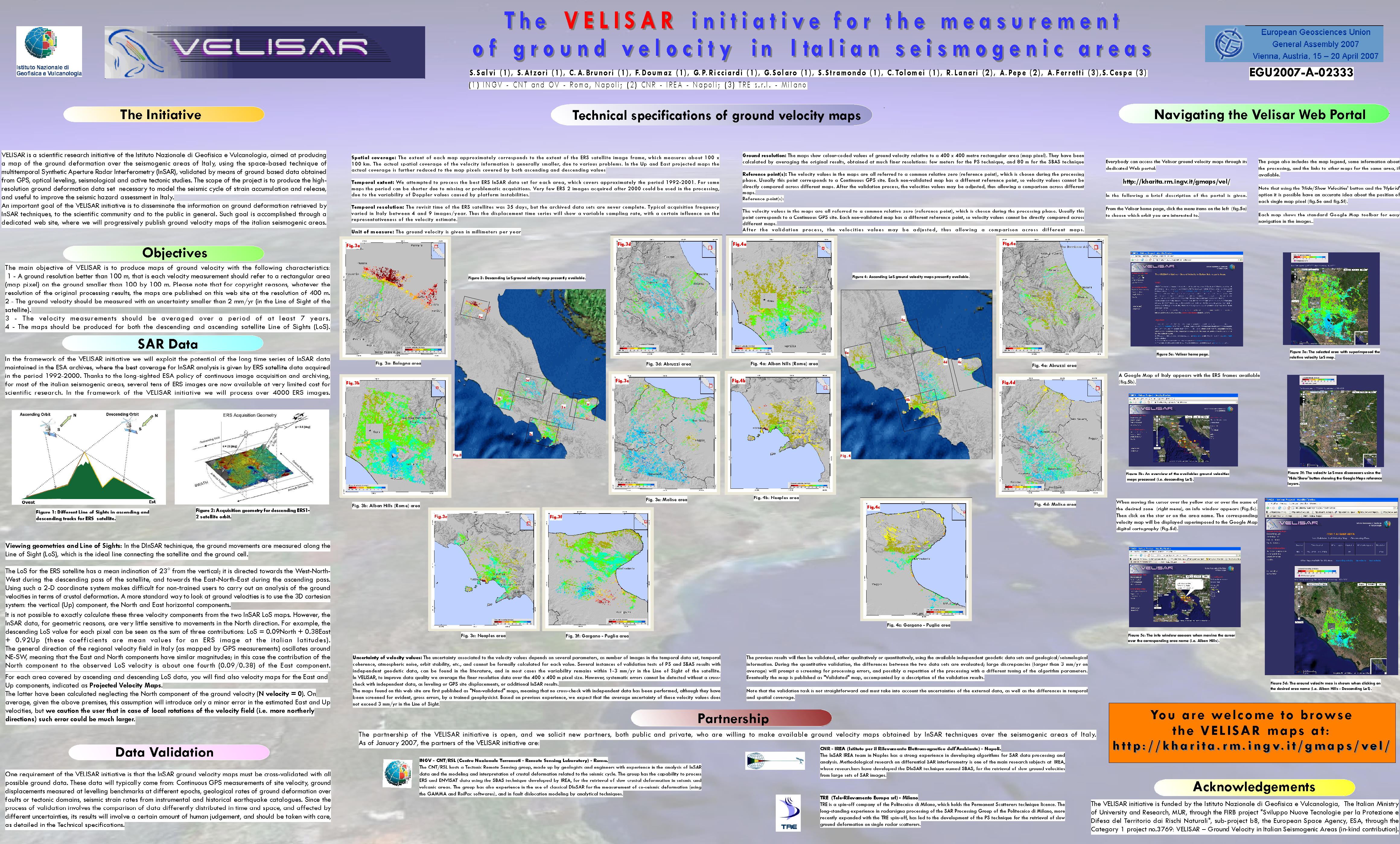 View/Open |
Page view(s) 50
223
checked on Apr 24, 2024
Download(s) 1
2,084
checked on Apr 24, 2024
