Please use this identifier to cite or link to this item:
http://hdl.handle.net/2122/6787| DC Field | Value | Language |
|---|---|---|
| dc.contributor.authorall | Pezzo, Giuseppe; Istituto Nazionale di Geofisica e Vulcanologia, Sezione CNT, Roma, Italia | en |
| dc.contributor.authorall | Tolomei, Cristiano; Istituto Nazionale di Geofisica e Vulcanologia, Sezione CNT, Roma, Italia | en |
| dc.contributor.authorall | Atzori, Simone; Istituto Nazionale di Geofisica e Vulcanologia, Sezione CNT, Roma, Italia | en |
| dc.contributor.authorall | Salvi, Stefano; Istituto Nazionale di Geofisica e Vulcanologia, Sezione CNT, Roma, Italia | en |
| dc.date.accessioned | 2011-01-20T12:00:42Z | en |
| dc.date.available | 2011-01-20T12:00:42Z | en |
| dc.date.issued | 2010-04 | en |
| dc.identifier.uri | http://hdl.handle.net/2122/6787 | en |
| dc.description.abstract | The Gargano Promontory (southern Italy) is an ENE-WSW oriented topographical and structural high, located in the Adriatic foreland between the Apennines and the Dinarides-Albanides fold-and-thrust belts. The stratigraphy of the area is characterized by a succession of Neogene shallow-water rocks (Early Miocene to Late Pliocene age), that unconformably covers the Mesozoic substratum. The entire succession is dissected by a complex and active fault system: the most prominent and the most active evidence of these structures is the Mattinata fault. In general a shared kinematic interpretation of the Gargano structure still does not exist and the debate is still open. In fact, previous works have inferred a reverse, right-lateral, left-lateral or inverted kinematic for the Mattinata fault, while the NW-SE fault system, located north of the Mattinata fault, has been interpreted either as a normal or a reverse fault system. The understanding of the kinematics related to the Gargano area plays an important role for the development of a new geodynamical model of the Appenninic outer deformation front and, ultimately, could provide important insights into the evolution of the Africa-Eurasia plate boundary in the central Mediterranean region. Another central point is that, although the Gargano area is located in the foreland, it is seismically active: the present level of the background seismicity is low (maximum magnitude Mw=5.4 occurring in the central part of the promontory), but destructive earthquakes (and even a tsunami) have occurred in historical times, with felt effects up to XI MCS. We have investigated the surface deformation by InSAR methodology: we have obtained ground motion time series using PS (Permanent Scatter) and SBAS (Small BAseline Subset) processing techniques. Both methods allow us to generate long time series of displacement and to analyse the velocity variation during that time. In the PS technique only the natural targets, showing a good stability of the backscattered signal in all the images, are considered for the calculation of the phase difference between acquisitions. In the SBAS approach, the entire image dataset is split into different subsets, characterized by small temporal and spatial baseline. With regard to the SBAS we have considered both ERS and ENVISAT orbits (93 descending and 47 ascending data) to obtain time series starting from 1992 to 2006. Instead the PS technique has been applied to the Gargano area using 83 ERS1-2 images relative to descending orbit and 31 images from ascending orbit respectively, in the period 1992-2002. We interpret the velocity fields retrieved by SBAS/PS technique in term of interseismic strain accumulation and propose some preliminary model to describe the underlying kinematic mechanism. | en |
| dc.language.iso | English | en |
| dc.relation.ispartof | European Geoscience Union, General assembly 2010 | en |
| dc.subject | InSAR | en |
| dc.subject | Remote Sensing | en |
| dc.title | The Gargano promontory: interseismic deformation growth by ground motion time series analysis | en |
| dc.type | Poster session | en |
| dc.description.status | Published | en |
| dc.subject.INGV | 04. Solid Earth::04.07. Tectonophysics::04.07.07. Tectonics | en |
| dc.description.ConferenceLocation | Wien, EGU2010-511 | en |
| dc.relation.references | -Argnani, A, M.Rovere, C. Bonazzi, 2009, Tectonics of the Mattinata fault, offshore south Gargano (southern Adriatic Sea, Italy): Implications for active deformation and seismotectonics in the foreland of the Southern Apennines, Geol. Soc. Of America Bull., Sept/Oct 2009 -Argnani, A., P. Favali, F. Frugoni, M. Gasperini, M. Ligi, M. Marani, G. Mattietti, and G. Mele 1993, Foreland deformational pattern in the southern Adriatic Sea, Ann.Geofis., 36(2), 229 ñ247. -Castello, B., G. Selvaggi, C. Chiarabba, and A. Amato, 2005, CSI Catalogo della sismicita` Italiana 1981 ñ 2002, version 1.0, Ist. Naz. di Geofis. e Vulcanol.- Centro Naz. Terremoti, Rome. (Available at http:// www.ingv.it/CSI/) -Ciaranfi, N., P. Pieri, and G. Ricchetti, 1988, Note alla carta geologica delle Murge e del Salento (Puglia centromeridionale), Mem. Soc. Geol. Ital., 41, 449 ñ 460. -Berardino, P., Fornaro, G., Lanari, R. & Sansosti, E., 2002. A new algorithm for surface deformation monitoring based on small baseline differential SAR interferograms, IEEE Trans. Geosci. Remote Sens., 40, 2375–2383. -Billi, A., 2003, Solution slip and separations on strikeslip fault zones: Theory and application to the Mattinata fault, Italy, J. Struct. Geol., 25, 703 ñ 715. -Billi, A., R. Gambini, C. Nicolai, and F. Storti, 2007, Neogene-Quaternary intraforeland transpressional along a Mesozoic platform-basin margin: the Gargano fault system, Adria, Italy: Geosphere, v. 3, p. 1-15, doi: 10.1130/GES00057.1. -Boschi, E., , E. Guidoboni, G. Ferrari, D. Mariotti, G. Valensise, and P. Gasperini (Eds.) 2000, Catalogue of strong Italian earthquakes from 461 B. C. to 1997, Ann.Geophys., 43(4), 608 ñ 868. -Brankman, C.M., Aydin, A., 2004, Uplift and contractional deformation along a segmented strike-slip fault system: the Gargano. J. Struct. Geol. 26, 807- 824. -Del Gaudio, V., P. Pierri, A. Frepoli, G. Calcagnile, N. Venisti, G.B. Cimini, A critical revision of the seismicity of northern Apulia (Adriatic microplate/southern Italy) and implications for the identification of seismogenic structures, Tectonophysics, v. 436, p. 9-35. doi 10.1016/j.tecto.2007.02.013. -Ferretti, A., C. Prati, and F. Rocca 2001, Permanent scatterers in SAR interferometry,IEEE Trans. Geosci. Remote Sens., 39(1), 8ñ 20. -Galadini, F., C. Meletti, and A. Rebez (Eds.), 2000, Le ricerche del GNDT nel campo della pericolosita` sismica (1996 ñ 1999), 397 pp., CNR-Gruppo Naz. Difesa dai Terremoti, Rome. -Gruppo di Lavoro, 1999, Catalogo Parametrico dei Terremoti Italiani, 92 pp., INGñGNDT ñSGAñ SSN, Bologna, Italy. -Kirkpatrick, S., Gelatt, C. D. and Vecchi,M. P., 1983, Optimization by simulated annealing. Science, 220, 671ñ680. Milano, G., R. Di Giovambattista, and G. Ventura 2005, Seismic constraints on the present-day kinematics of the Gargano foreland, Italy, at the transition zone between the southern and northern Apennine belts, Geophys. Res. Lett., 32. -Morelli, D., 2002, Evoluzione tettonico-stratigrafica del Margine Adriatico compreso tra il Promontorio Garganico e Brindisi: Memorie della Societ‡ Geologica Italiana, v. 57, p. 343ñ353. -Nelder, J.A. and Mead, R., 1965. A simplex method for function minimization. Comput. J., 7, 308ñ313.slip fault system: the Gargano. J. Struct. Geol. 26, 807ñ 824. -Okada, Y., 1985. Surface deformation due to shear and tensile faults in a half-space. Bull. Seismol. Soc. Am., 75, 1135ñ1154. -Patacca, E., and P. Scandone, 2004, The 1627 Gargano earthquake (southern Italy): Identification and characterization of the causative fault, J. Seismol., 8, 259ñ 273. -Salvi, S., Quattrocchi, F., Brunori, C.A., Doumaz, F., Angelone, M., Billi, A., Buongiorno, F., Funiciello, R., Guerra, M., Mele, G., Pizzino, L. and Salvini, F., 2000, A multidisciplinary approach to earthquake research: implementation of a Geochemical Geographic Information System for the Gargano site, southern Italy. Nat. Hazards 20, 255ñ278. -Salvi S., et al. (2004), Inflation rate of the Colli Albani volcanic complex retrieved by the permanent scatterers SAR interferometry technique, GEOPHYSICAL RESEARCH LETTERS, VOL. 31, 2004 -Salvini F., Billi A., Wise, D. U., 1999, Strike-slip fault-propagation cleavage in carbonate rocks: the Mattinata fault Zone, Southern Apennines, Italy, J. Struct. Geol. 21, 1731ñ1749. -Valensise G., D. Pantosti, R. Basili, 2004, Seismology and tectonic setting of the 2002 Molise, Italy, earthquake: Earthquake Spectra, v. 20, p. S23-S37 | en |
| dc.description.obiettivoSpecifico | 1.10. TTC - Telerilevamento | en |
| dc.description.fulltext | open | en |
| dc.contributor.author | Pezzo, Giuseppe | en |
| dc.contributor.author | Tolomei, Cristiano | en |
| dc.contributor.author | Atzori, Simone | en |
| dc.contributor.author | Salvi, Stefano | en |
| dc.contributor.department | Istituto Nazionale di Geofisica e Vulcanologia (INGV), Sezione ONT, Roma, Italia | en |
| dc.contributor.department | Istituto Nazionale di Geofisica e Vulcanologia (INGV), Sezione ONT, Roma, Italia | en |
| dc.contributor.department | Istituto Nazionale di Geofisica e Vulcanologia (INGV), Sezione ONT, Roma, Italia | en |
| dc.contributor.department | Istituto Nazionale di Geofisica e Vulcanologia (INGV), Sezione ONT, Roma, Italia | en |
| item.openairetype | Poster session | - |
| item.cerifentitytype | Publications | - |
| item.languageiso639-1 | en | - |
| item.grantfulltext | open | - |
| item.openairecristype | http://purl.org/coar/resource_type/c_18cf | - |
| item.fulltext | With Fulltext | - |
| crisitem.author.dept | Istituto Nazionale di Geofisica e Vulcanologia (INGV), Sezione ONT, Roma, Italia | - |
| crisitem.author.dept | Istituto Nazionale di Geofisica e Vulcanologia (INGV), Sezione ONT, Roma, Italia | - |
| crisitem.author.dept | Istituto Nazionale di Geofisica e Vulcanologia (INGV), Sezione ONT, Roma, Italia | - |
| crisitem.author.dept | Istituto Nazionale di Geofisica e Vulcanologia (INGV), Sezione ONT, Roma, Italia | - |
| crisitem.author.orcid | 0000-0003-4851-4193 | - |
| crisitem.author.orcid | 0000-0001-7378-0712 | - |
| crisitem.author.orcid | 0000-0002-5031-9904 | - |
| crisitem.author.orcid | 0000-0002-7776-6544 | - |
| crisitem.author.parentorg | Istituto Nazionale di Geofisica e Vulcanologia | - |
| crisitem.author.parentorg | Istituto Nazionale di Geofisica e Vulcanologia | - |
| crisitem.author.parentorg | Istituto Nazionale di Geofisica e Vulcanologia | - |
| crisitem.author.parentorg | Istituto Nazionale di Geofisica e Vulcanologia | - |
| crisitem.classification.parent | 04. Solid Earth | - |
| crisitem.department.parentorg | Istituto Nazionale di Geofisica e Vulcanologia | - |
| crisitem.department.parentorg | Istituto Nazionale di Geofisica e Vulcanologia | - |
| crisitem.department.parentorg | Istituto Nazionale di Geofisica e Vulcanologia | - |
| crisitem.department.parentorg | Istituto Nazionale di Geofisica e Vulcanologia | - |
| Appears in Collections: | Conference materials | |
Files in This Item:
| File | Description | Size | Format | |
|---|---|---|---|---|
| Pezzo_et_al_EGU2010.jpg | The Gargano promontory: interseismic deformation by ground motion time series analysis | 1.04 MB | JPEG | 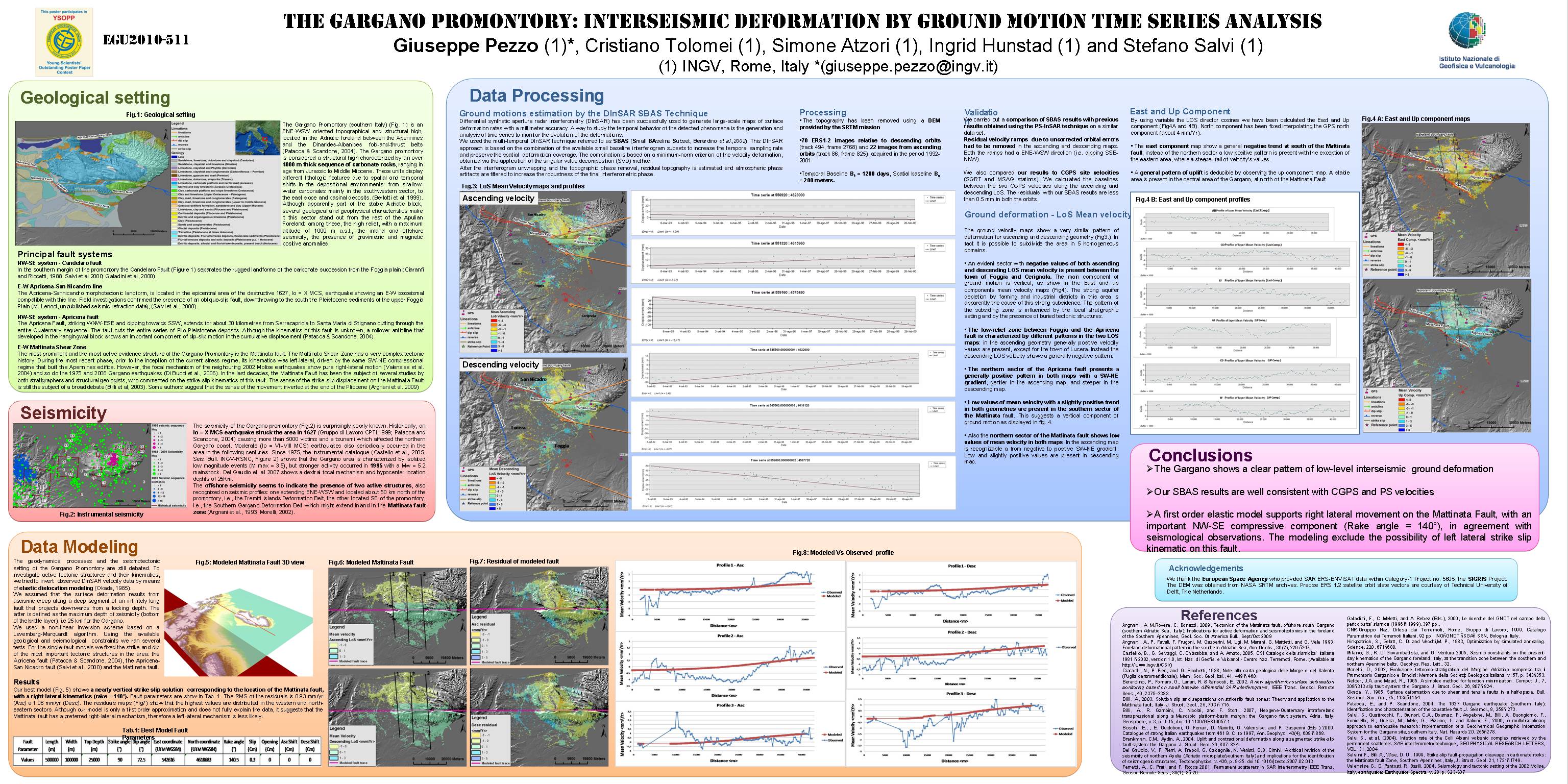 View/Open |
Page view(s) 50
204
checked on Apr 17, 2024
Download(s)
57
checked on Apr 17, 2024
